Fichier:Iceland Mid-Atlantic Ridge map.svg

Gréisst vun dëser PNG-Duerstellung vun dësem SVG-Fichier: 376 × 390 Pixel. Aner Opléisungen: 231 × 240 Pixel | 463 × 480 Pixel | 740 × 768 Pixel | 987 × 1.024 Pixel | 1.974 × 2.048 Pixel.
Original-Fichier (SVG-Fichier, Basisgréisst: 376 × 390 Pixel, Gréisst vum Fichier: 129 KB)
Resumé
| Beschreiwung | |
| Datum | |
| Quell | http://pubs.usgs.gov/gip/dynamic/understanding.html |
| Auteur | http://pubs.usgs.gov/gip/dynamic/understanding.html |
| Aner Versiounen |
|


Lizenz
Dieses Bild ist gemeinfrei (public domain), weil es Materialien beeinhaltet, die ursprünglich vom United States Geological Survey, einer Behörde des Innenministeriums der Vereinigten Staaten, stammen. Weitere Informationen finden Sie in den Urheberrechtsbestimmungen des USGS
|
| Annotations | This image is annotated: View the annotations at Commons |
Versiounen
Klickt op e bestëmmten Zäitpunkt fir déi respektiv Versioun vum Fichier ze kucken.
| Versioun vum | Miniaturbild | Dimensiounen | Benotzer | Bemierkung | |
|---|---|---|---|---|---|
| aktuell | 18:48, 10. Jan. 2014 | | 376 × 390 (129 KB) | Amitchell125 | text improved |
| 14:42, 26. Feb. 2010 |  | 376 × 390 (68 KB) | Beao | Tweak. | |
| 14:40, 26. Feb. 2010 |  | 376 × 390 (68 KB) | Beao | Tweak. | |
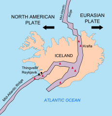
| 14:37, 26. Feb. 2010 |  | 376 × 390 (68 KB) | Beao | == Summary == {{Information |Description={{en|1=Map showing the Mid-Atlantic Ridge splitting Iceland and separating the North American and Eurasian Plates. The map also shows Reykjavik, the capital of Iceland, the Thingvellir area, and the locations of so |
Benotze vu Fichieren
Dës Säite benotzen dëse Fichier:
Globaalt Benotze vum Fichier
Dës aner Wikie benotzen dëse Fichier:
- Benotzt op be-tarask.wikipedia.org
- Benotzt op bn.wikipedia.org
- Benotzt op ca.wikipedia.org
- Benotzt op en.wikipedia.org
- Benotzt op en.wikivoyage.org
- Benotzt op fi.wikipedia.org
- Benotzt op hr.wikipedia.org
- Benotzt op id.wikipedia.org
- Benotzt op it.wikipedia.org
- Benotzt op ko.wikipedia.org
- Benotzt op nl.wikipedia.org
- Benotzt op no.wikipedia.org
- Benotzt op pl.wikipedia.org
- Benotzt op simple.wikipedia.org
- Benotzt op sl.wikipedia.org
- Benotzt op sr.wikipedia.org
- Benotzt op sv.wikipedia.org
- Benotzt op tr.wikipedia.org
- Benotzt op uk.wikipedia.org
- Benotzt op zh.wikipedia.org
- Benotzt op zh.wikivoyage.org