Fichier:St. Martin.png

Gréisst vun dëser Duerstellung: 800 × 566 Pixel. Aner Opléisungen: 320 × 227 Pixel | 640 × 453 Pixel | 1.024 × 725 Pixel | 1.280 × 906 Pixel | 2.560 × 1.812 Pixel | 5.563 × 3.938 Pixel.
Original-Fichier (5.563 × 3.938 Pixel, Fichiersgréisst: 6,29 MB, MIME-Typ: image/png)
Resumé
| Beschreiwung |
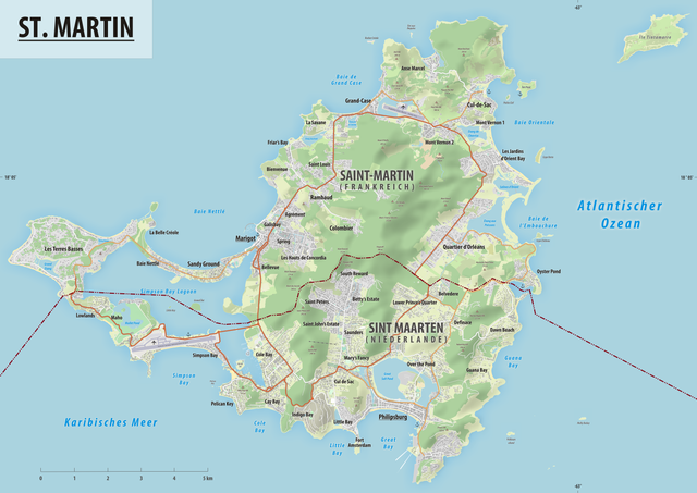
Deutsch: Reliefkarte des Grenzverlaufes zwischen Frankreich und der Niederlande |
||||||||
| Datum | |||||||||
| Quell | Eegent Wierk, Hintergrund: Openstreetmap | ||||||||
| Auteur | Tschubby | ||||||||
| Autorisatioun (Dëse Fichier nach eng Kéier benotzen) |
Ech, deen deen d'Auteursrechter vun dësem Wierk huet, verëffentlechen et heimat ënner dëse Lizenzen:
Dëse Fichier steent ënner der Creative Commons Attribution-Share Alike 2.5 Generic, 2.0 Generic an der 1.0 Generic Lizenz.
Dir kënnt d'Lizenz vun Ärer Wiel eraussichen. |

Versiounen
Klickt op e bestëmmten Zäitpunkt fir déi respektiv Versioun vum Fichier ze kucken.
| Versioun vum | Miniaturbild | Dimensiounen | Benotzer | Bemierkung | |
|---|---|---|---|---|---|
| aktuell | 08:54, 17. Aug. 2019 | | 5.563 × 3.938 (6,29 MB) | Tschubby | {{Information |description= |date= |source= |author= |permission= |other versions= }} |
| 08:20, 17. Aug. 2019 |  | 5.563 × 3.938 (6,29 MB) | Tschubby | == {{int:filedesc}} == {{Information |Description= {{de| Reliefkarte des Grenzverlaufes zwischen Frankreich und Monaco}} |Source={{own}}, Hintergrund: [http://www.openstreetmap.org Openstreetmap] |Date= 2019-08-17 |Author= Tschubby |Permission= {{self|GFDL|Cc-by-sa-3.0-migrated|Cc-by-sa-2.5,2.0,1.0}} |other_versions= }} Category:Borders of France-Nederlands Category:Maps of borders of Nederlands Category:Maps of borders of France |
Benotze vu Fichieren
Dës Säit benotzt dëse Fichier:
Globaalt Benotze vum Fichier
Dës aner Wikie benotzen dëse Fichier:
- Benotzt op ar.wikipedia.org
- Benotzt op ca.wikipedia.org
- Benotzt op de.wikipedia.org
- Benotzt op gl.wikipedia.org
- Benotzt op tt.wikipedia.org
- Benotzt op www.wikidata.org