Fichier:SpainDueroBasin.png

Gréisst vun dëser Duerstellung: 800 × 572 Pixel. Aner Opléisungen: 320 × 229 Pixel | 640 × 457 Pixel | 1.024 × 732 Pixel | 1.280 × 915 Pixel | 1.748 × 1.249 Pixel.
Original-Fichier (1.748 × 1.249 Pixel, Fichiersgréisst: 2,55 MB, MIME-Typ: image/png)
Resumé
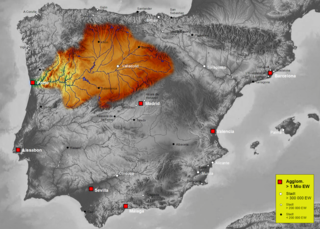
| Beschreiwung | Map of Duero river basin in Spain, Karte des hydrogeografischen Beckens des Duero |
| Datum | |
| Quell | Own work, based on an image of http://www.maps-for-free.com/ (Creative Commons Attribution Share Alike 3.0) |
| Auteur | Port(u*o)s |
| Autorisatioun (Dëse Fichier nach eng Kéier benotzen) |
Creative Commons Attribution Share Alike 3.0 |
Lizenz
Dëse Fichier ass ënner der Creative Commons Attribution-Share Alike 3.0 Unported Lizenz disponibel.
- Dir kënnt:
- D'Wierk deelen – kopéieren, verdeelen a weiderginn
- D'Wierk kombinéieren – adaptéieren
- Ënner dëse Konditiounen:
- Attributioun – Dir musst appropriéiert Informatiounen iwwer den Auteur uginn, e Link op d'Lizenz maachen, an uginn ob Ännerunge gemaach goufen. Dës Informatioune kënnen op eng räsonabel Manéier gi ginn, awer ouni datt den Androck entsteet datt deen deen d'Lizenz ginn huet Iech oder Är Benotzung approuvéiert oder ënnerstëtzt.
- ënner deselwechte Bedingunge weiderginn – Wann Dir dëst Wierk ännert, transforméiert oder dorop opbaut, dierft Dir dat Wierk, dat doraus entsteet, nëmmen ënner der selwechter oder enger kompatibeler Lizenz, verbreeden.
Versiounen
Klickt op e bestëmmten Zäitpunkt fir déi respektiv Versioun vum Fichier ze kucken.
| Versioun vum | Miniaturbild | Dimensiounen | Benotzer | Bemierkung | |
|---|---|---|---|---|---|
| aktuell | 16:41, 7. Okt. 2021 | | 1.748 × 1.249 (2,55 MB) | Lojwe | Santiago mal posicionada |
| 01:51, 5. Feb. 2019 |  | 1.748 × 1.249 (2,11 MB) | TouchName | recorte de marco | |
| 02:07, 30. Okt. 2007 |  | 1.808 × 1.307 (2,57 MB) | Port(u*o)s | == Summary == {{Information |Description=Map of Duero river basin in Spain, Karte des hydrogeografischen Beckens des Duero |Source= Own work, based on an image of http://www.maps-for-free.com/ (Creative Commons Attribution Share Alike 3.0) |Date=October 2 |
Benotze vu Fichieren
Dës Säit benotzt dëse Fichier:
Globaalt Benotze vum Fichier
Dës aner Wikie benotzen dëse Fichier:
- Benotzt op af.wikipedia.org
- Benotzt op ast.wikipedia.org
- Benotzt op ca.wikipedia.org
- Benotzt op cs.wikipedia.org
- Benotzt op cv.wikipedia.org
- Benotzt op de.wikipedia.org
- Benotzt op el.wikipedia.org
- Benotzt op eo.wikipedia.org
- Benotzt op es.wikipedia.org
- Duero
- Río Carrión
- Pisuerga
- Eresma
- Adaja
- Río Arlanza
- Río Aliste
- Río Tera
- Río Zapardiel
- Río Guareña
- Río Huebra
- Río Jerga
- Úrbel
- Voltoya
- Río Duratón
- Río Margañán
- Anexo:Ríos de España
- Usuario discusión:NACLE
- Río Malo
- Cuenca hidrográfica del Duero
- Río Valdeginate
- Río Almar
- Río Grande (afluente del Carrión)
- Río Arevalillo
- Plantilla:Ficha de cuerpo de agua
- Plantilla:Ficha de cuerpo de agua/doc
- Río Negro (afluente del Omaña)
- Río Navajos
- Río Valdesamario
- Río Castro (afluente del Tera)
- Río Manzanas
- Río Tuela
- Río Gamoneda
- Río Truchas
- Río Cueza
Kuckt globale Gebrauch vun dësem Fichier.