Fichier:Martinique legende arrs.PNG
Et gëtt keng méi héich Opléisung.
Martinique_legende_arrs.PNG (419 × 478 Pixel, Fichiersgréisst: 16 KB, MIME-Typ: image/png)
Resumé
| Beschreiwung |
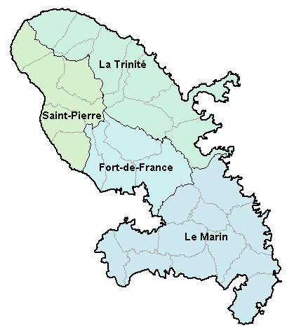
Carte de la Martinique avec ses 4 arrondissements. Map of French department of Martinique with its 4 "arrondissements". |
| Datum | 2. Januar 2007 (Original-Hochladedatum) |
| Quell | No machine-readable source provided. Own work assumed (based on copyright claims). |
| Auteur | No machine-readable author provided. BigonL assumed (based on copyright claims). |
Lizenz
| Ich, der Urheberrechtsinhaber dieses Werkes, veröffentliche es als gemeinfrei. Dies gilt weltweit. An eenzele Länner ass dat legal net méiglech; an deem Fall: Ech ginn heimat jiddwerengem d'Recht dëst Wierk fir all Zweck ze benotzen, ouni iergendeng Konditioun, ausser de Konditiounen déi vum Gesetz verlaangt sinn. |
Versiounen
Klickt op e bestëmmten Zäitpunkt fir déi respektiv Versioun vum Fichier ze kucken.
| Versioun vum | Miniaturbild | Dimensiounen | Benotzer | Bemierkung | |
|---|---|---|---|---|---|
| aktuell | 16:48, 2. Jan. 2007 | | 419 × 478 (16 KB) | BigonL | Carte de la Martinique avec ses 4 arrondissements. Map of French department of Martinique with its 4 "arrondissements". |
Benotze vu Fichieren
Dës Säit benotzt dëse Fichier:
Globaalt Benotze vum Fichier
Dës aner Wikie benotzen dëse Fichier:
- Benotzt op cs.wikipedia.org
- Benotzt op cv.wikipedia.org
- Benotzt op el.wikipedia.org
- Benotzt op en.wikipedia.org
- Benotzt op es.wikipedia.org
- Benotzt op fa.wikipedia.org
- Benotzt op fr.wikipedia.org
- Benotzt op gl.wikipedia.org
- Benotzt op is.wikipedia.org
- Benotzt op it.wikipedia.org
- Benotzt op ka.wikipedia.org
- Benotzt op mk.wikipedia.org
- Benotzt op oc.wikipedia.org
- Fort-de-France
- Comunas de Martinica
- Modèl:Comunas de Martinica
- L'Ajoupa-Bouillon
- Les Anses-d'Arlet
- Basse-Pointe
- Le Carbet
- Case-Pilote
- Le Diamant
- Ducos
- Fonds-Saint-Denis
- Le François
- Grand'Rivière
- Gros-Morne
- Le Lamentin
- Le Lorrain
- Macouba
- Le Marigot
- Le Marin
- Le Morne-Rouge
- Le Prêcheur
- Rivière-Pilote
- Rivière-Salée
- Le Robert
- Saint-Esprit
- Saint-Joseph (Martinica)
- Saint-Pierre (Martinica)
- Sainte-Luce (Martinica)
- Schœlcher
- La Trinité
- Les Trois-Îlets
- Le Vauclin
- Le Morne-Vert
- Bellefontaine (Martinica)
- Sainte-Marie (Martinica)
- Sainte-Anne (Martinica)
- Benotzt op pl.wikipedia.org
Kuckt globale Gebrauch vun dësem Fichier.