Fichier:Mare Tranquillitatis map.jpg
Et gëtt keng méi héich Opléisung.
Mare_Tranquillitatis_map.jpg (343 × 344 Pixel, Fichiersgréisst: 69 KB, MIME-Typ: image/jpeg)
Resumé
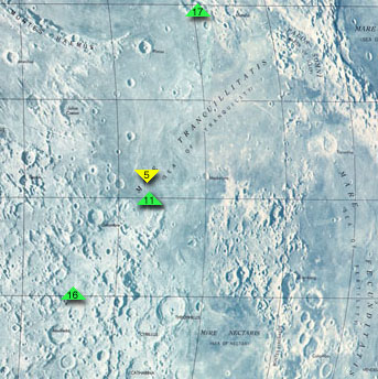
Map of Mare Tranquillitatis, cropped from http://www.jpl.nasa.gov/history/60s/Surveyor7_1968.htm.
The colored arrows indicate the landing sites of Apollo 11, the first manned moon mission, Apollo 17, Apollo 16, and Surveyor 5. To the southeast is Mare Fecunditatis, to the northeast is Mare Crisium, and to the south is Mare Nectaris.
Secondary source: http://en.wikipedia.org/wiki/Image:Mare_Tranquillitatis_map.jpg
Lizenz
| Diese Datei ist gemeinfrei (public domain), da sie von der NASA erstellt worden ist. Die NASA-Urheberrechtsrichtlinie besagt, dass „NASA-Material nicht durch Urheberrecht geschützt ist, wenn es nicht anders angegeben ist“. (NASA-Urheberrechtsrichtlinie-Seite oder JPL Image Use Policy). | ||
 |
Warnung:
|
Versiounen
Klickt op e bestëmmten Zäitpunkt fir déi respektiv Versioun vum Fichier ze kucken.
| Versioun vum | Miniaturbild | Dimensiounen | Benotzer | Bemierkung | |
|---|---|---|---|---|---|
| aktuell | 23:00, 25. Aug. 2005 | | 343 × 344 (69 KB) | Mattes | new |
Benotze vu Fichieren
Dës Säit benotzt dëse Fichier:
Globaalt Benotze vum Fichier
Dës aner Wikie benotzen dëse Fichier:
- Benotzt op af.wikipedia.org
- Benotzt op bg.wikipedia.org
- Benotzt op cs.wikipedia.org
- Benotzt op da.wikipedia.org
- Benotzt op de.wikipedia.org
- Benotzt op en.wikipedia.org
- Benotzt op es.wikipedia.org
- Benotzt op fa.wikipedia.org
- Benotzt op fi.wikipedia.org
- Benotzt op fr.wikipedia.org
- Benotzt op he.wikipedia.org
- Benotzt op id.wikipedia.org
- Benotzt op it.wikipedia.org
- Benotzt op ka.wikipedia.org
- Benotzt op ko.wikipedia.org
- Benotzt op nl.wikipedia.org
- Benotzt op pl.wikipedia.org
- Benotzt op pt.wikipedia.org
- Benotzt op ro.wikipedia.org
- Benotzt op ru.wikipedia.org
- Benotzt op simple.wikipedia.org
- Benotzt op sv.wikipedia.org
- Benotzt op zh.wikipedia.org