Fichier:Haiti topographic map-fr.png

Gréisst vun dëser Duerstellung: 800 × 598 Pixel. Aner Opléisungen: 320 × 239 Pixel | 640 × 478 Pixel | 1.024 × 765 Pixel | 1.280 × 956 Pixel | 1.739 × 1.299 Pixel.
Original Fichier (1.739 × 1.299 Pixel, Fichiersgréisst: 2,21 MB, MIME-Typ: image/png)
Resumé
| Beschreiwung |
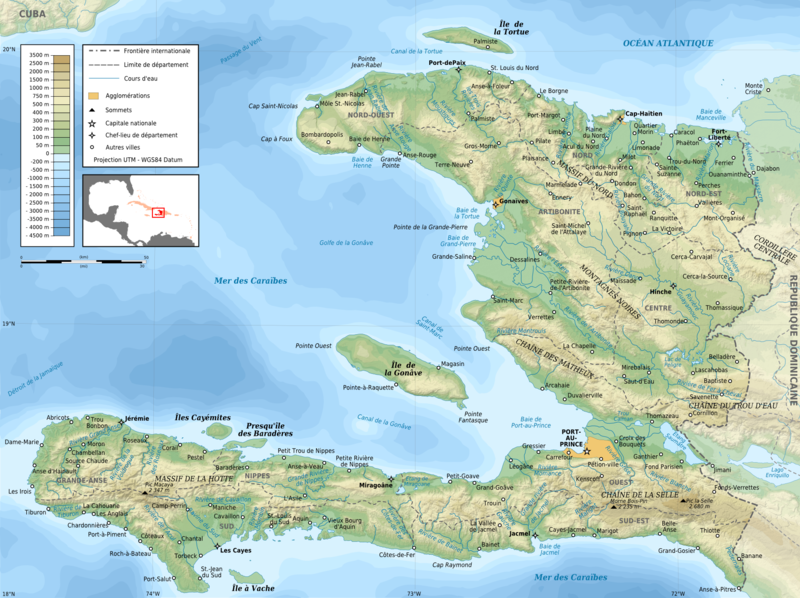
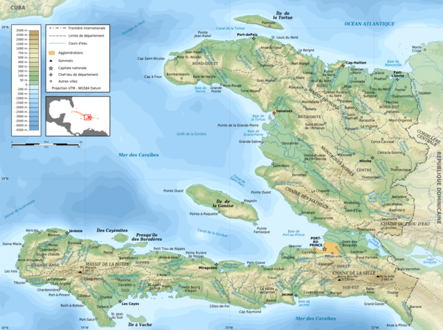
English: Topographic map of Haiti in French. Use the SVG version for translations and alterations, then update this one.
Français : Carte topographique d'Haïti en français. Utiliser la version SVG pour les traductions et les changements, puis mettre à jour celle-ci.
|
| Datum | |
| Quell |
Own work. Sources of data:
|
| Auteur | Rémi Kaupp |
| Aner Versiounen |
[]
|


Lizenz
English: This map has been created by Rémi Kaupp (User:Korrigan) and released under the license(s) stated below. You are free to use it for any purpose as long as you credit me and follow the terms of the license. You may need to credit the sources of data of the map (please check). Example:
Français : Cette carte a été créée par Rémi Kaupp (User:Korrigan) et placée sous la ou les licence(s) ci-dessous. Vous êtes libre de la réutiliser, tant que vous me citez en tant qu'auteur et suivez les instructions de la licence. Certaines sources de données de la carte doivent peut-être être créditées, veuillez vérifier. Exemple :
|
 |
Ech, deen deen d'Auteursrechter vun dësem Wierk huet, verëffentlechen et heimat ënner dëse Lizenzen:

|
Et ass erlaabt, dëse Fichier ënner de Bedingunge vun der GNU-Lizenz fir fräi Dokumentatioun, an der Versioun 1.2 oder enger spéiderer Versioun, verëffentlecht vun der Free Software Foundation, ze kopéieren, ze verbreeden an/oder zu modifizéieren, ouni onverännerlech Abschnitter, Ëmschlagtext virdrun, Ëmschlagtext hannendrun. De kompletten Text vun der Lizenz ass am Kapitel GNU-Lizenz fir fräi Dokumentatioun ze gesinn. |
This file is licensed under the Creative Commons Attribution-Share Alike 4.0 International, 3.0 Unported, 2.5 Generic, 2.0 Generic and 1.0 Generic license.
- Dir kënnt:
- D'Wierk deelen – kopéieren, verdeelen a weiderginn
- D'Wierk kombinéieren – adaptéieren
- Ënner dëse Konditiounen:
- Attributioun – Dir musst appropriéiert Informatiounen iwwer den Auteur uginn, e Link op d'Lizenz maachen, an uginn ob Ännerunge gemaach goufen. Dës Informatioune kënnen op eng räsonabel Manéier gi ginn, awer ouni datt den Androck entsteet datt deen deen d'Lizenz ginn huet Iech oder Är Benotzung approuvéiert oder ënnerstëtzt.
- ënner deselwechte Bedingunge weiderginn – Wann Dir dëst Wierk ännert, transforméiert oder dorop opbaut, dierft Dir dat Wierk, dat doraus entsteet, nëmmen ënner der selwechter oder enger kompatibeler Lizenz, verbreeden.
Dir kënnt d'Lizenz vun Ärer Wiel eraussichen.
Versiounen
Klickt op e bestëmmten Zäitpunkt fir déi respektiv Versioun vum Fichier ze kucken.
| Versioun vum | Miniaturbild | Dimensiounen | Benotzer | Bemierkung | |
|---|---|---|---|---|---|
| aktuell | 19:26, 11. Mäe. 2009 | | 1.739 × 1.299 (2,21 MB) | Korrigan | + masque blanc pour pays étrangers |
| 22:49, 9. Mäe. 2009 |  | 1.739 × 1.299 (2,22 MB) | Korrigan | Recadrage de la carte de situation | |
| 22:30, 9. Mäe. 2009 |  | 1.739 × 1.299 (2,22 MB) | Korrigan | - cadre, + chaînes de montagne, meilleure carte de situation | |
| 00:37, 7. Mäe. 2009 |  | 1.739 × 1.299 (2,21 MB) | Korrigan | == Description == {{Information |Description={{en|Topographic map of Haiti in French}} {{fr|Carte topographique d'Haïti en français.}} * UTM projection, WGS84 datum * The shaded relief is an embedded raster image, delete it to make the file smaller. |
Benotze vu Fichieren
Dës Säit benotzt dëse Fichier:
Globaalt Benotze vum Fichier
Dës aner Wikie benotzen dëse Fichier:
- Benotzt op ar.wikipedia.org
- Benotzt op avk.wikipedia.org
- Benotzt op ca.wikipedia.org
- Benotzt op ceb.wikipedia.org
- Benotzt op de.wikipedia.org
- Benotzt op en.wikipedia.org
- Benotzt op eo.wikipedia.org
- Benotzt op es.wikipedia.org
- Benotzt op fa.wikipedia.org
- Benotzt op fr.wikipedia.org
- Discussion Wikipédia:Atelier graphique/Archive 4
- Géographie d'Haïti
- Artibonite (fleuve)
- Projet:Cartographie/Cartes standards/Pays
- Histoire de la caféiculture
- Wikipédia:Image du jour/mai 2009
- Wikipédia:Image du jour/12 mai 2009
- Massif de la Hotte
- Chaîne de la Selle
- Rivière Soliette
- Chaîne des Matheux
- Massif des Montagnes Noires
- Rivière de Montrouis
- Chaîne du Trou d'Eau
- Massif du Nord
- Rivière des Ténèbres
- Rivière Libon
- Rivière Macassia
- Rivière Fer à Cheval
- Pedernales (rivière)
- Rivière Limbé
- Grande Rivière du Nord
- Rivière Bouyaha
- Liste de catastrophes naturelles en Haïti
- Rivière Guayamouc
- Rivière l'Estère
- Rivière Blanche (département de l'Ouest)
- Rivière Grise
- Rivière de Cavaillon
- Ravine du Sud
- Liste des cours d'eau d'Haïti
- Rivière Torbeck
- Acul du Sud
- Rivière Bainet
- Grande Rivière de Nippes
- Rivière de la Cosse
Kuckt globale Gebrauch vun dësem Fichier.