Fichier:Djerba topographic map-fr.svg

Gréisst vun dëser PNG-Duerstellung vun dësem SVG-Fichier: 666 × 599 Pixel. Aner Opléisungen: 267 × 240 Pixel | 533 × 480 Pixel | 853 × 768 Pixel | 1.138 × 1.024 Pixel | 2.276 × 2.048 Pixel | 1.100 × 990 Pixel.
Original Fichier (SVG-Fichier, Basisgréisst: 1.100 × 990 Pixel, Gréisst vum Fichier: 564 KB)
Resumé
| Kamerapositioun | | Dëst an aner Biller op OpenStreetMap |
|---|
| Beschreiwung |
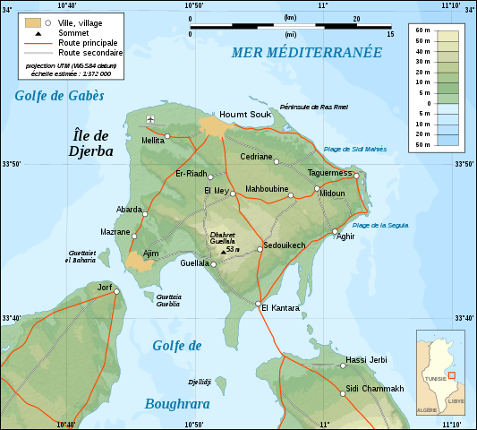
English: Topographic map in French of Djerba Island, Tunisia.
Note: The shaded relief is a raster image embedded in the SVG file. Français : Carte topographique en français de l'île de Djerba, Tunisie.
Note : Les ombres du relief sont une image bitmap embarquée dans le fichier SVG. Norsk bokmål: Topografisk kart over Djerba i Tunisia, på fransk.
UTM projection ; WGS84 datum ; shaded relief (composite image of N-W and N lightning positions) ; |
||
| Datum | |||
| Quell |
Own work ;
|
||
| Auteur | Eric Gaba (Sting - fr:Sting) | ||
| Autorisatioun (Dëse Fichier nach eng Kéier benotzen) |
|
||
| Aner Versiounen |
Derivative works of this file: []
|


|
This SVG file contains embedded text that can be translated into your language, using any capable SVG editor, text editor or the SVG Translate tool. For more information see: About translating SVG files. |
Lizenz
Ech, deen deen d'Auteursrechter vun dësem Wierk huet, verëffentlechen et heimat ënner dëse Lizenzen:

|
Et ass erlaabt, dëse Fichier ënner de Bedingunge vun der GNU-Lizenz fir fräi Dokumentatioun, an der Versioun 1.2 oder enger spéiderer Versioun, verëffentlecht vun der Free Software Foundation, ze kopéieren, ze verbreeden an/oder zu modifizéieren, ouni onverännerlech Abschnitter, Ëmschlagtext virdrun, Ëmschlagtext hannendrun. De kompletten Text vun der Lizenz ass am Kapitel GNU-Lizenz fir fräi Dokumentatioun ze gesinn. |
This file is licensed under the Creative Commons Attribution-Share Alike 4.0 International, 3.0 Unported, 2.5 Generic, 2.0 Generic and 1.0 Generic license.
- Dir kënnt:
- D'Wierk deelen – kopéieren, verdeelen a weiderginn
- D'Wierk kombinéieren – adaptéieren
- Ënner dëse Konditiounen:
- Attributioun – Dir musst appropriéiert Informatiounen iwwer den Auteur uginn, e Link op d'Lizenz maachen, an uginn ob Ännerunge gemaach goufen. Dës Informatioune kënnen op eng räsonabel Manéier gi ginn, awer ouni datt den Androck entsteet datt deen deen d'Lizenz ginn huet Iech oder Är Benotzung approuvéiert oder ënnerstëtzt.
- ënner deselwechte Bedingunge weiderginn – Wann Dir dëst Wierk ännert, transforméiert oder dorop opbaut, dierft Dir dat Wierk, dat doraus entsteet, nëmmen ënner der selwechter oder enger kompatibeler Lizenz, verbreeden.
Dir kënnt d'Lizenz vun Ärer Wiel eraussichen.
Versiounen
Klickt op e bestëmmten Zäitpunkt fir déi respektiv Versioun vum Fichier ze kucken.
| Versioun vum | Miniaturbild | Dimensiounen | Benotzer | Bemierkung | |
|---|---|---|---|---|---|
| aktuell | 01:09, 1. Sep. 2008 | | 1.100 × 990 (564 KB) | Sting | New standard colors |
| 20:07, 5. Dez. 2007 |  | 1.100 × 990 (571 KB) | Sting | Forgotten village name | |
| 10:44, 5. Dez. 2007 |  | 1.100 × 990 (571 KB) | Sting | "Ras Rmel" typo correction | |
| 23:11, 4. Dez. 2007 |  | 1.100 × 990 (571 KB) | Sting | {{Location|33|45|00|N|10|55|00|E|scale:500000}} <br/> {{Information |Description=Topographic map in French of Djerba Island, Tunisia |Source=Own work ;<br/>Topographic map : [http://www2.jpl.nasa.gov/srtm NASA Shuttle Radar Topography Missi |
Benotze vu Fichieren
Et gëtt keng Säiten, déi dëse Fichier benotzen.
Globaalt Benotze vum Fichier
Dës aner Wikie benotzen dëse Fichier:
- Benotzt op da.wikipedia.org
- Benotzt op en.wikipedia.org
- Benotzt op eo.wikipedia.org
- Benotzt op fa.wikipedia.org
- Benotzt op fr.wikipedia.org
- Benotzt op fr.wiktionary.org
- Benotzt op gl.wikipedia.org
- Benotzt op he.wikipedia.org
- Benotzt op incubator.wikimedia.org
- Benotzt op it.wikipedia.org
- Benotzt op lad.wikipedia.org
- Benotzt op pl.wikipedia.org
- Benotzt op pt.wikipedia.org
- Benotzt op sco.wikipedia.org
- Benotzt op sc.wikipedia.org