Fichier:Bolama sectors.png
Gréisst vun dëser Duerstellung: 738 × 599 Pixel. Aner Opléisungen: 296 × 240 Pixel | 591 × 480 Pixel | 948 × 770 Pixel.
Original-Fichier (948 × 770 Pixel, Fichiersgréisst: 24 KB, MIME-Typ: image/png)
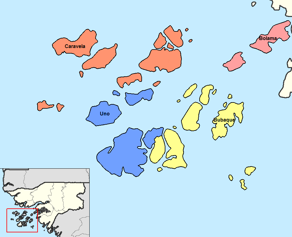
Português: Sectores de Bolama até 2004.
Deutsch: Sektoren der Region Bolama bis 2004.
English: Sectors od the Bolama region until 2004.
Resumé
| Beschreiwung | Map of the sectors of Bolama region of Guinea-Bissau. Created by Rarelibra 14:13, 14 September 2006 (UTC) for public domain use, using MapInfo Professional v8.5 and various mapping resources. |
| Datum | 5. Januar 2008 (Original-Hochladedatum) |
| Quell | No machine-readable source provided. Own work assumed (based on copyright claims). |
| Auteur | No machine-readable author provided. Francofranco56 assumed (based on copyright claims). |
| Aner Versiounen |
|

Lizenz
| Ich, der Urheberrechtsinhaber dieses Werkes, veröffentliche es als gemeinfrei. Dies gilt weltweit. An eenzele Länner ass dat legal net méiglech; an deem Fall: Ech ginn heimat jiddwerengem d'Recht dëst Wierk fir all Zweck ze benotzen, ouni iergendeng Konditioun, ausser de Konditiounen déi vum Gesetz verlaangt sinn. |
Versiounen
Klickt op e bestëmmten Zäitpunkt fir déi respektiv Versioun vum Fichier ze kucken.
| Versioun vum | Miniaturbild | Dimensiounen | Benotzer | Bemierkung | |
|---|---|---|---|---|---|
| aktuell | 10:16, 19. Aug. 2015 | | 948 × 770 (24 KB) | Naturals | Uno sector since 2004 |
| 11:50, 18. Aug. 2015 |  | 948 × 770 (24 KB) | Naturals | colors | |
| 11:46, 18. Aug. 2015 |  | 948 × 770 (24 KB) | Naturals | ||
| 10:23, 5. Jan. 2008 |  | 1.056 × 816 (30 KB) | Francofranco56 | Map of the sectors of Bolama region of Guinea-Bissau. Created by Rarelibra 14:13, 14 September 2006 (UTC) for public domain use, using MapInfo Professional v8.5 and various mapping resources. == Licensing == {{PD-self}} |
Benotze vu Fichieren
Dës Säit benotzt dëse Fichier:
Globaalt Benotze vum Fichier
Dës aner Wikie benotzen dëse Fichier:
- Benotzt op ca.wikipedia.org
- Benotzt op cs.wikipedia.org
- Benotzt op de.wikipedia.org
- Benotzt op en.wikipedia.org
- Benotzt op eo.wikipedia.org
- Benotzt op es.wikipedia.org
- Benotzt op et.wikipedia.org
- Benotzt op fi.wikipedia.org
- Benotzt op frr.wikipedia.org
- Benotzt op fr.wikipedia.org
- Benotzt op it.wikipedia.org
- Benotzt op ja.wikipedia.org
- Benotzt op ko.wikipedia.org
- Benotzt op lt.wikipedia.org
- Benotzt op nl.wikipedia.org
- Benotzt op pt.wikipedia.org
- Benotzt op ro.wikipedia.org
- Benotzt op ru.wikipedia.org
- Benotzt op tr.wikipedia.org
- Benotzt op uk.wikipedia.org
- Benotzt op zh.wikipedia.org