Fichier:Map of Sealand with territorial waters.png

Original-Fichier(1.174 × 1.200 Pixel, Fichiersgréisst: 55 KB, MIME-Typ: image/png)

Dëse Fichier ass vu(n) Wikimedia Commons an däerf vun anere Projete benotzt ginn. D'Beschreiwung op senger Beschreiwungssäit steet hei ënnendrënner.

Beschreiwung

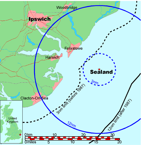
Map of Sealand

This is a map of the coast of England near Ipswich, showing the location of Sealand. The boundaries of the territorial water of the United Kingdom are also drawn, both the 3 nautical mile limit (5.556km) before 1987 and the 12nm limit (22.22km) after 1987. The same radii are also given around Sealand.

Note that these boundaries are derived based on the circular distance from the coastline, and not copied from official maps. This map is not suitable for navigation or for determining the boundaries of the UK territorial waters for legal or other purposes.

Createur
Map generated by DEMIS World Map Server and edited by Chris 73
Autorisatioun
(Dëse Fichier nach eng Kéier benotzen)


Licensing:

This image was created by Chris 73. The image is licensed under a dual license; please choose either of the two licenses below as desired. Attribution to Wikipedia or another project of the Wikimedia foundation is required for both licenses if the image is used outside of projects of the Wikimedia foundation. Attribution to me is not required.

GNU head Es ist erlaubt, die Datei unter den Bedingungen der GNU-Lizenz für freie Dokumentation, Version 1.3 oder einer späteren Version, veröffentlicht von der Free Software Foundation, zu kopieren, zu verbreiten und/oder zu modifizieren; es gibt keine unveränderlichen Abschnitte, keinen vorderen und keinen hinteren Umschlagtext.

Der vollständige Text der Lizenz ist im Kapitel GNU-Lizenz für freie Dokumentation verfügbar.

w:lb:Creative Commons
Attributioun ënner deselwechte Bedingunge weiderginn
Dëse Fichier ass ënner der Creative Commons Attribution-Share Alike 3.0 Unported Lizenz disponibel.
Attributioun: Chris 73 / Wikimedia Commons
Dir kënnt:
  • D'Wierk deelen – kopéieren, verdeelen a weiderginn
  • D'Wierk kombinéieren – adaptéieren
Ënner dëse Konditiounen:
  • Attributioun – Dir musst appropriéiert Informatiounen iwwer den Auteur uginn, e Link op d'Lizenz maachen, an uginn ob Ännerunge gemaach goufen. Dës Informatioune kënnen op eng räsonabel Manéier gi ginn, awer ouni datt den Androck entsteet datt deen deen d'Lizenz ginn huet Iech oder Är Benotzung approuvéiert oder ënnerstëtzt.
  • ënner deselwechte Bedingunge weiderginn – Wann Dir dëst Wierk ännert, transforméiert oder dorop opbaut, dierft Dir dat Wierk, dat doraus entsteet, nëmmen ënner der selwechter oder enger kompatibeler Lizenz, verbreeden.

"I want to use the image. How do I do that?"

You can use this image freely for any purpose, including commercial use, provided that you license it under one of the above licenses. My suggestion is to use the following text:

This Wikipedia and Wikimedia Commons image is from the user Chris 73 and is freely available at //commons.wikimedia.org/wiki/File:Map_of_Sealand_with_territorial_waters.png under the creative commons cc-by-sa 3.0 license.

For privacy reasons please use only "Chris 73" as author. If necessary, please translate the text in your language. For electronic use please include the links in the text as shown, for printed use please print the text as shown. If you use the image I would appreciate it if you would let me know on my talk page, but this is not required as long as you follow one of the above licenses.


 Kartografische Angaben
Räumliche Begrenzung
N: 52.1374339°N
W: 0.9973602°E E: 1.6619722°E
S: 51.6274989°N
Georeferenzierung Betrachte die Karte projiziert auf einer aktuellen Karte mit dem Wikimaps Warper

Beschreiwungen

Setzt eng Erklärung an enger Zeil derbäi wat dëse Fichier duerstellt

In dieser Datei abgebildete Objekte

Motiv

MIME-Typ Däitsch

image/png

Prüfsumme Däitsch

845a9e08cbe7ed93bae6eeabe454399a76e3324f

Dateigröße Däitsch

56.131 Byte

1.200 Pixel

1.174 Pixel

Versiounen

Klickt op e bestëmmten Zäitpunkt fir déi respektiv Versioun vum Fichier ze kucken.

Versioun vumMiniaturbildDimensiounenBenotzerBemierkung
aktuell19:41, 9. Jul. 2006Miniaturbild fir d'Versioun vum 19:41, 9. Jul. 20061.174 × 1.200 (55 KB)Chris 73update
10:00, 26. Jan. 2005Miniaturbild fir d'Versioun vum 10:00, 26. Jan. 20051.024 × 1.046 (50 KB)Chris 73

Dës Säit benotzt dëse Fichier:

Globaalt Benotze vum Fichier

Dës aner Wikie benotzen dëse Fichier: