Fichier:ISS-20 Caribbean island of Hispaniola from the ISS.jpg
Gréisst vun dëser Duerstellung: 800 × 532 Pixel. Aner Opléisungen: 320 × 213 Pixel | 640 × 426 Pixel | 1.024 × 681 Pixel | 1.280 × 852 Pixel | 2.560 × 1.703 Pixel | 4.256 × 2.832 Pixel.
Original-Fichier (4.256 × 2.832 Pixel, Fichiersgréisst: 1,17 MB, MIME-Typ: image/jpeg)
Resumé
| Beschreiwung |
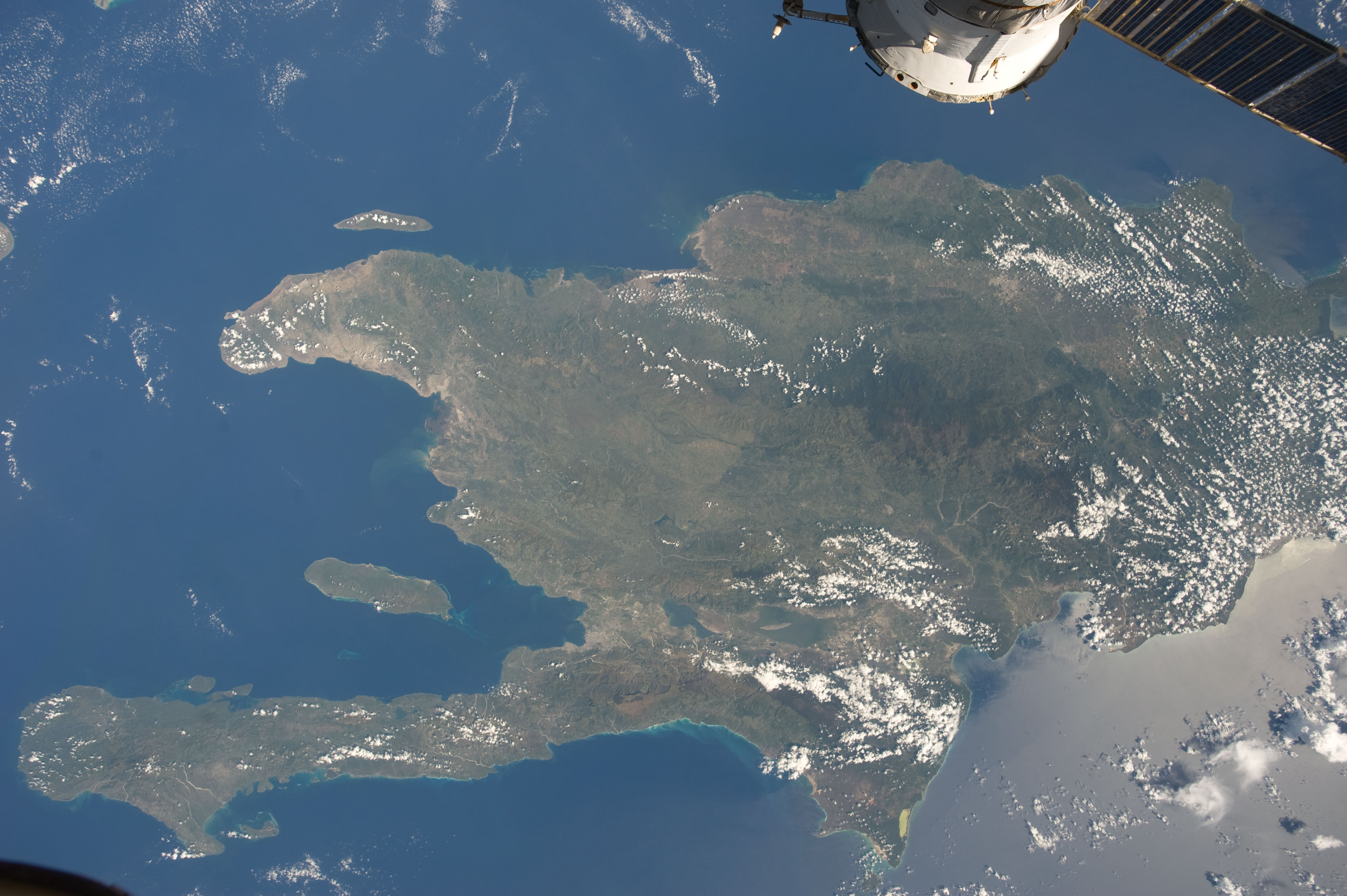
English: A view of the Caribbean island of Hispaniola from the International Space Station. This island is comprised of Haiti (in the center left of the image) and the Dominican Republic and is part of the Greater Antilles island chain which lies along the geological border of the North America Plate and the Caribbean Plate. A major fault line in the region, Enriquillo-Plantain Garden Fault, runs along the longer peninsula, in the foreground, and just south of Port-au-Prince. Part of a docked Russian spacecraft can be seen in the foreground. The epicenter of the disastrous 2010 earthquake occurred near this fault. This image was taken by the Expedition 20 crew on the International Space Station on Sept. 28, 2009 using a 25 mm lens setting. |
| Datum | |
| Quell | http://spaceflight.nasa.gov/gallery/images/station/crew-20/html/iss020e043301.html |
| Auteur | NASA/Expedition 20 crew |
| Aner Versiounen |
Diese Mediendatei wurde vom Johnson Space Center der US-amerikanischen National Aeronautics and Space Administration (NASA) unter der Datei-ID ISS020-E-043301 kategorisiert. Diese Markierung zeigt nicht den Urheberrechtsstatus des zugehörigen Werks an. Es ist in jedem Falle zusätzlich eine normale Lizenzvorlage erforderlich. Siehe Commons:Lizenzen für weitere Informationen. Sprachen:
|
Lizenz
| Diese Datei ist gemeinfrei (public domain), da sie von der NASA erstellt worden ist. Die NASA-Urheberrechtsrichtlinie besagt, dass „NASA-Material nicht durch Urheberrecht geschützt ist, wenn es nicht anders angegeben ist“. (NASA-Urheberrechtsrichtlinie-Seite oder JPL Image Use Policy). | ||
 |
Warnung:
|
Versiounen
Klickt op e bestëmmten Zäitpunkt fir déi respektiv Versioun vum Fichier ze kucken.
| Versioun vum | Miniaturbild | Dimensiounen | Benotzer | Bemierkung | |
|---|---|---|---|---|---|
| aktuell | 20:18, 22. Jun. 2012 | | 4.256 × 2.832 (1,17 MB) | Ras67 | {{Information |Description={{en|1=A view of the Caribbean island of Hispaniola from the International Space Station. This island is comprised of Haiti (in the center left of the image) and the Dominican Republic and is part of the Greater Antilles isla... |
Benotze vu Fichieren
Dës Säit benotzt dëse Fichier:
Globaalt Benotze vum Fichier
Dës aner Wikie benotzen dëse Fichier:
- Benotzt op ar.wikipedia.org
- Benotzt op ast.wikipedia.org
- Benotzt op az.wikipedia.org
- Benotzt op ba.wikipedia.org
- Benotzt op ca.wikipedia.org
- Benotzt op ceb.wikipedia.org
- Benotzt op cy.wikipedia.org
- Benotzt op de.wikipedia.org
- Benotzt op es.wikipedia.org
- Benotzt op eu.wikipedia.org
- Benotzt op fi.wiktionary.org
- Benotzt op fr.wikivoyage.org
- Benotzt op ga.wikipedia.org
- Benotzt op hsb.wikipedia.org
- Benotzt op ht.wikipedia.org
- Benotzt op hy.wikipedia.org
- Benotzt op ia.wikipedia.org
- Benotzt op no.wikipedia.org
- Benotzt op pap.wikipedia.org
- Benotzt op pl.wikipedia.org
- Benotzt op pnb.wikipedia.org
- Benotzt op ro.wikipedia.org
- Benotzt op sv.wikipedia.org
- Benotzt op tg.wikipedia.org
- Benotzt op uk.wikipedia.org
- Benotzt op uz.wikipedia.org
- Benotzt op vec.wikipedia.org
- Benotzt op www.wikidata.org