Fichier:European microstates map.svg

Gréisst vun dëser PNG-Duerstellung vun dësem SVG-Fichier: 553 × 600 Pixel. Aner Opléisungen: 221 × 240 Pixel | 442 × 480 Pixel | 708 × 768 Pixel | 944 × 1.024 Pixel | 1.888 × 2.048 Pixel.
Original-Fichier (SVG-Fichier, Basisgréisst: 553 × 600 Pixel, Gréisst vum Fichier: 1,18 MB)
Resumé
| Beschreiwung |
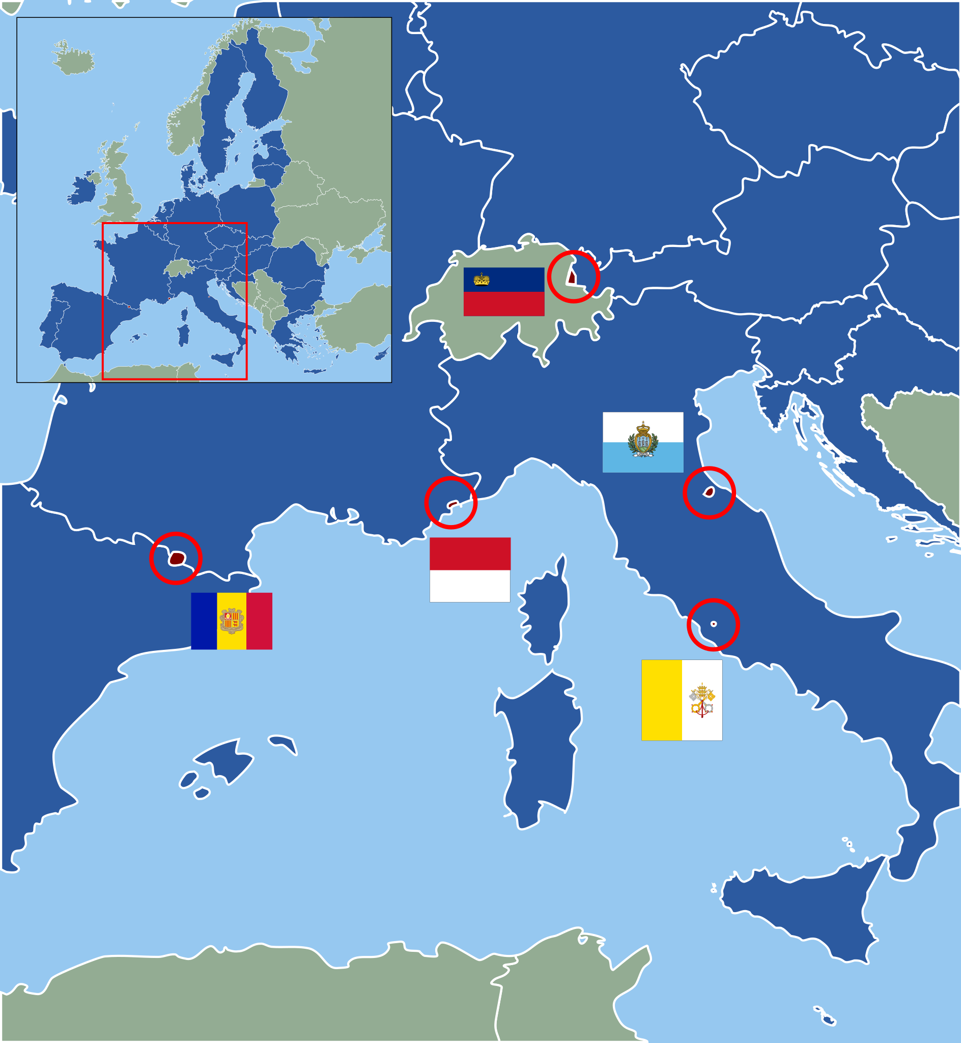
Deutsch: Karte der europäischen Zwergstaaten und der Europäischen Union (2013). Staaten der EU sind blau, Zuordnung der Mikrostaaten nach ihren Flaggen wie folgt:
English: Map of European Microstates and the European Union in 2013. The European Union is in blue, microstate flags as follows:
|
| Datum | (UTC) |
| Quell | |
| Auteur |
|
| Dieses Bild wurde digital nachbearbeitet. Folgende Änderungen wurden vorgenommen: Vectorization under usage of blank svg map. Das Originalbild kann hier eingesehen werden: European Microstates Map.png:
|
Lizenz
Dëse Fichier ass ënner der Creative Commons Attribution-Share Alike 3.0 Unported Lizenz disponibel.
- Dir kënnt:
- D'Wierk deelen – kopéieren, verdeelen a weiderginn
- D'Wierk kombinéieren – adaptéieren
- Ënner dëse Konditiounen:
- Attributioun – Dir musst appropriéiert Informatiounen iwwer den Auteur uginn, e Link op d'Lizenz maachen, an uginn ob Ännerunge gemaach goufen. Dës Informatioune kënnen op eng räsonabel Manéier gi ginn, awer ouni datt den Androck entsteet datt deen deen d'Lizenz ginn huet Iech oder Är Benotzung approuvéiert oder ënnerstëtzt.
- ënner deselwechte Bedingunge weiderginn – Wann Dir dëst Wierk ännert, transforméiert oder dorop opbaut, dierft Dir dat Wierk, dat doraus entsteet, nëmmen ënner der selwechter oder enger kompatibeler Lizenz, verbreeden.
Original-Logbuch vum Eroplueden
This image is a derivative work of the following images:
- File:Blank_map_of_Europe.svg licensed with Cc-by-sa-2.5
- 2011-09-19T22:57:58Z Alphathon 680x520 (603759 Bytes) Added North/Northern Cyprus
- 2011-08-23T10:26:48Z Heb 680x520 (604212 Bytes) Added [[:en:Bornholm]] (taken from [[:File:Denmark blank map.svg]])
- 2011-04-12T00:40:40Z Alphathon 680x520 (602549 Bytes) Upgraded Sicily based on "File:Freeworldmaps-sicily.jpg". Upgraded Malta based on "File:Map of Malta 2.png". Simplified Croatian borders.
- 2011-04-10T21:43:04Z Alphathon 680x520 (607359 Bytes) Upgraded Croatia, Bosnia & Herzegovina, Slovenia and surrounding countries based on data from "File:Kroatien - Politische Gliederung (Karte).png"
- 2011-04-10T20:05:09Z Alphathon 680x520 (568373 Bytes) Improved Serbia, Montenegro and surrounding countries using data from "File:Serbia Map.png". Fixed Serbia-Montenegro border. Added Kosovo (using dashed border, since it is not a universally recognised nation, and left the lan
- 2011-04-10T15:55:02Z Alphathon 680x520 (524980 Bytes) Tweaked Ukraine and surrounding countries based on data from "File:Up-map.png"
- 2011-04-10T04:02:09Z Alphathon 680x520 (511168 Bytes) Improved Greece, Albania, F.Y.R. Macedonia and Bulgaria based on "File:Greece topo.jpg"
- 2011-04-10T02:48:52Z Alphathon 680x520 (505569 Bytes) Tweaked Germany and surrounding countries based on info from "File:Germany_general_map.png"
- 2011-04-10T01:54:05Z Alphathon 680x520 (493733 Bytes) Converted all lakes back to separate layer. Added Finish lakes and tweaked Finland shape based on "File:Finland 1996 CIA map.jpg". Added Swiss lakes based on "File:Suisse cantons.svg". Tweaked Scotland and added Lochs.
- 2011-04-10T00:07:54Z Alphathon 680x520 (450120 Bytes) Improved England outline and added Isle of Wight based on "File:England Regions - Blank.svg". Improved Denmark based on "File:2 digit postcode danmark.png". Improved Sweden based on "File:Map of Sweden, CIA, 1996.jpg"
- 2011-04-08T15:53:07Z Alphathon 680x520 (438878 Bytes) Upgraded/fixed various parts of the map. Details: *Some minor fixes to Ireland and added some of the larger lakes based on [[:File:Ireland_trad_counties_named.svg]] *Pretty major fixes to Scotland (mainly the west coast and i
- (10 more entrys follow)
- File:European_Microstates_Map.png licensed with PD-self
- 2007-06-20T12:16:46Z JLogan 212x217 (8731 Bytes) {{Information |Description=Map of European Microstates |Source=self-made |Date=12 March 2007 |Author= [[User:JLogan|JLogan]] }}
Hochgeladen mit derivativeFX
Versiounen
Klickt op e bestëmmten Zäitpunkt fir déi respektiv Versioun vum Fichier ze kucken.
| Versioun vum | Miniaturbild | Dimensiounen | Benotzer | Bemierkung | |
|---|---|---|---|---|---|
| aktuell | 13:04, 27. Feb. 2022 | | 553 × 600 (1,18 MB) | Welkend | own mistake corrected (Iceland) |
| 12:58, 27. Feb. 2022 |  | 553 × 600 (1,17 MB) | Welkend | own mistake corrected (red circle around Monaco) | |
| 12:56, 27. Feb. 2022 |  | 553 × 600 (1,17 MB) | Welkend | little cosmetic corrections of the borders of the map and the shape of Monaco | |
| 11:41, 2. Feb. 2020 |  | 553 × 600 (1,17 MB) | NordNordWest | upd | |
| 11:40, 30. Jun. 2013 |  | 553 × 600 (1,17 MB) | NordNordWest | upd | |
| 23:59, 9. Dez. 2011 |  | 553 × 600 (1,17 MB) | Master Uegly | == {{int:filedesc}} == {{Information |Description={{de|Karte der europäischen Zwergstaaten und der Europäischen Union (2010). Staaten der EU sind blau, Zuordnung der Mikrostaaten nach ihren Flaggen wie folgt:}} {{en|Map of European Microstates and the E |
Benotze vu Fichieren
Dës Säite benotzen dëse Fichier:
Globaalt Benotze vum Fichier
Dës aner Wikie benotzen dëse Fichier:
- Benotzt op az.wikipedia.org
- Benotzt op cs.wikipedia.org
- Benotzt op de.wikipedia.org
- Benotzt op es.wikipedia.org
- Benotzt op fa.wikipedia.org
- Benotzt op fi.wikipedia.org
- Benotzt op fr.wikipedia.org
- Benotzt op hr.wikipedia.org
- Benotzt op hy.wikipedia.org
- Benotzt op pl.wikipedia.org
- Benotzt op pt.wikipedia.org
- Benotzt op ru.wikipedia.org
- Benotzt op sv.wikipedia.org
- Benotzt op th.wikipedia.org
- Benotzt op uk.wikipedia.org
- Benotzt op www.wikidata.org
- Benotzt op zh.wikipedia.org