Fichier:Erebus 360 L257atc-B652R1.jpg

Gréisst vun dëser Duerstellung: 800 × 211 Pixel. Aner Opléisungen: 320 × 84 Pixel | 640 × 168 Pixel | 1.024 × 270 Pixel | 1.280 × 337 Pixel | 2.560 × 674 Pixel | 22.780 × 5.996 Pixel.
Original-Fichier (22.780 × 5.996 Pixel, Fichiersgréisst: 74,36 MB, MIME-Typ: image/jpeg)
| Warnung | Diese Originaldatei ist sehr hochauflösend. Es könnte sein, dass diese Datei nicht richtig geladen werden kann oder dass der Browser einfriert, wenn die Datei in voller Größe geöffnet wird. Um diese Probleme zu vermeiden, kann der interaktive Bildbetrachter (ZoomViewer) verwendet werden. |
|---|
Resumé
| Beschreiwung |
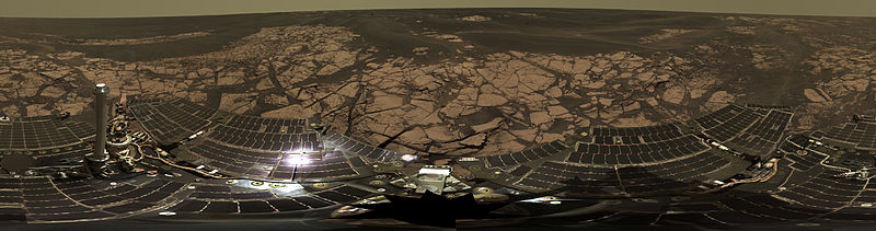
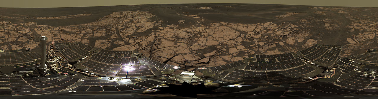
English: This is the Opportunity panoramic camera's "Erebus Rim" panorama, acquired on sols 652 to 663 (Nov. 23 to Dec. 5, 2005 ), as NASA's Mars Exploration Rover Opportunity was exploring sand dunes and outcrop rocks in Meridiani Planum. The panorama originally consisted of 635 separate images in four different Pancam filters, and covers 360 degrees of terrain around the rover and the full rover deck. Since the time that this panorama was acquired, and while engineers have been diagnosing and testing Opportunity's robotic arm, the panorama has been expanded to include more than 1,300 images of this terrain through all of the Pancam multispectral filters. It is the largest panorama acquired by either rover during the mission.
The panorama shown here is an approximate true-color rendering using Pancam's 750 nanometer, 530 nanometer and 430 nanometer filters. It is presented here as a cylindrical projection. Image-to-image seams have been eliminated from the sky portion of the mosaic to better simulate the vista a person standing on Mars would see. This panorama provides the team's highest resolution view yet of the finely-layered outcrop rocks, wind ripples, and small cobbles and grains along the rim of the wide but shallow "Erebus" crater. Once the arm diagnostics and testing are completed, the team hopes to explore other layered outcrop rocks at Erebus and then eventually continue southward toward the large crater known as "Victoria." |
| Datum | zwischen 23. November 2005 und 5. Dezember 2005 |
| Quell | http://marsrovers.jpl.nasa.gov/gallery/press/opportunity/20060104a.html / http://photojournal.jpl.nasa.gov/catalog/PIA03270 |
| Auteur | NASA/JPL-Caltech/Cornell |
| 360° | Dieses Bild in einem interaktiven Panoramabetrachter ansehen.
|
|---|
Diese Mediendatei wurde vom Jet Propulsion Lab der US-amerikanischen National Aeronautics and Space Administration (NASA) unter der Datei-ID PIA03270 kategorisiert. Diese Markierung zeigt nicht den Urheberrechtsstatus des zugehörigen Werks an. Es ist in jedem Falle zusätzlich eine normale Lizenzvorlage erforderlich. Siehe Commons:Lizenzen für weitere Informationen. Sprachen:
|
Lizenz
| Diese Datei ist gemeinfrei (public domain), da sie von der NASA erstellt worden ist. Die NASA-Urheberrechtsrichtlinie besagt, dass „NASA-Material nicht durch Urheberrecht geschützt ist, wenn es nicht anders angegeben ist“. (NASA-Urheberrechtsrichtlinie-Seite oder JPL Image Use Policy). | ||
 |
Warnung:
|
Versiounen
Klickt op e bestëmmten Zäitpunkt fir déi respektiv Versioun vum Fichier ze kucken.
| Versioun vum | Miniaturbild | Dimensiounen | Benotzer | Bemierkung | |
|---|---|---|---|---|---|
| aktuell | 06:00, 22. Feb. 2013 | 22.780 × 5.996 (74,36 MB) | Huntster | Original super-resolution version of image. | |
| 10:50, 15. Jan. 2006 | 3.000 × 790 (523 KB) | JamesHoadley | w:Erebus crater. From [http://marsrovers.jpl.nasa.gov/gallery/press/opportunity/20060104a.html]. Original caption: <blockquote>'''On the Rim of 'Erebus'''' This is the Opportunity panoramic camera's "Erebus Rim" panorama, acquired on sols 652 to 66 |
Benotze vu Fichieren
Dës Säit benotzt dëse Fichier:
Globaalt Benotze vum Fichier
Dës aner Wikie benotzen dëse Fichier:
- Benotzt op ast.wikipedia.org
- Benotzt op bs.wikipedia.org
- Benotzt op de.wikipedia.org
- Benotzt op en.wikipedia.org
- Benotzt op es.wikipedia.org
- Benotzt op fr.wikipedia.org
- Benotzt op hi.wikipedia.org
- Benotzt op it.wikipedia.org
- Benotzt op ja.wikipedia.org
- Benotzt op ko.wikipedia.org
- Benotzt op mn.wikipedia.org
- Benotzt op pt.wikipedia.org
- Benotzt op ro.wikipedia.org
- Benotzt op ru.wikipedia.org
- Benotzt op uk.wikipedia.org
- Benotzt op zh.wikipedia.org